
Royston road names revealed
If they know nothing else about their history, Royston residents are aware that the town stands at the crossroads of two great Roman roads – Ermine Street and Icknield Way – which are themselves believed to be ancient British trackways, though some would dispute this.
In the town centre, Icknield Way has now become Baldock Street to the west and Melbourn Street to the East, while Ermine Street follows the route of Royston High Street, before travelling north along what is now known as Kneesworth Street and towards Huntingdon on Old North Road or, as it is less romantically named beyond the A505, the A1198. For fans of travel trivia: before the reconfiguration around Caxton and Papworth, the A1198 between Royston and the A14 was, at 19 miles, the longest straightest stretch of road in the country.
As befits the confluence of two major trading routes, Royston has enjoyed an abundance of inns and beer houses through the centuries (there are more than 60 identified sites and there were 48 pubs in Royston in 1900) refreshing weary travellers and their animals and, as a by-product, giving names to many of Royston’s thoroughfares.
Sun Hill takes its name from the Sun public house which stood at the bottom; a building now called Sun Hill Cottage – named after the hill, not the pub; confused? In a more contemporary cultural connection, Geoff McQueen, creator of the long-running (1983 – 2010) TV police series ‘The Bill’ says the name for his fictional Sun Hill Police Station came from his home town of Royston.
Mounteagle – a somewhat more dramatically named road that’s a stone’s throw from Sun Hill – has historical connections with events of national importance. It was Lord Mounteagle – a courtier of King James 1st – who, in October 1605, passed intelligence to the King that led to the discovery of Guy Fawkes and the Gunpowder Plot.
The naming of Angel Pavement is relatively recent but has an association with another public house from the past. The Angel was once located at the High Street end of the current precinct, the Red Lion at the other. F John Smith – who in the early 1960s was a new councillor with the then Royston Urban District Council – proposed the current name. As he writes in his booklet ‘A Royston Miscellany’: “Apart from it sounding nicer [than Red Lion Court] it calls to mind J.B.Priestley’s famous novel of that title.”
The Angel in this part of town should not be confused with the Angel Inn once located in what is now Lower King Street (called Back Street until 1911). Back Street itself was previously known as Dow Street or Dead Street (an association with residents there that succumbed to the plague that most tourist offices would probably rather forget). Of further interest is that the Hertfordshire/ Cambridgeshire border once ran down the route of Icknield Way, and some records show Deade Streate on the Hertfordshire side. But you can still see why it was changed to Back Street.
Down the High Street, parallel to Angel Pavement, George Lane has three claims to local fame – as the only cobbled street in Royston and, at the Market Hill end, the location of the Plough, Royston’s smallest pub until it closed in 1928. But it’s the former George inn that once refreshed travellers at the High Street end of George Lane that is of note for something more serious – the death in 1733 of James Blood, killed when the inn’s sign fell on him as drove his wagon up the High Street.
Royston’s royal connections explain many of the road names – with Kings, Queens and Coronations all referenced. More interesting perhaps is Dog Kennel Lane behind the Old Palace; a reference to the building that housed the King’s hunting dogs on the eastern boundary of the royal estate.
A more intriguing canine connection relates to Serby Avenue. F. John Smith writes. “It was built through a field whose owner Mr Falahee, had a dog that he thought he was naming after Cerberus, the mythological dog at the gates of Hades. But his spelling was poor so he would call his dog to heel with the cry ‘serby, serby’”.
For linguists with a passion for regional dialects, a couple of Royston road names will be of particular interest. Pightle is a Norfolk word, being a small piece of enclosed land, with some sources suggesting a pightle is also associated with a house. This explains the naming of Pightle Close (off Kneesworth Street) which was developed in the garden of a house called The Pightle, although the enclosure with animals is likely to have pre-dated the house with people.
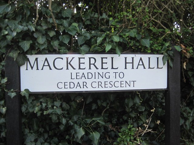
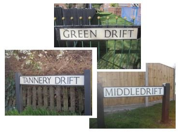
Also from Norfolk dialect is drift – a drove road – partly explaining Tannery Drift, Green Drift and Middle Drift. Apparently that area used to be called Driftway, which is also the name of a road in Reed. In the same part of Royston, there’s a vaguer explanation for Mackerel Hall, named after a group of cottages where… ‘it’s suggested a seller of fish lived in one of the cottages’. However, according to another informant, the name relates to a Lord, rather than a fish. The evidence for a small Tannery nearby in Tannery Drift (called Tanyard Drift in the early 1900s) seems to be stronger.
Three – water, wind and fire – of the five elements of nature are reflected in road names around Mill Road from times gone by. The ‘mill’ refers to a windmill that stood in an orchard 100 yards from Melbourn Road. References to the windmill date back to 1363 and it existed at least until 1676. The orchard became Gage Close (a hint about the fruit grown there). From ‘air’ to ‘water’ – Queens Road, named in honour of Queen Victoria and located across Kneesworth Street from the railway station, used to be called Water Street after the pumping station near the junction. In 1896, the Water Street facility was inadequate to meet the demands of the growing town and this was superseded by the ‘new works’ on London Road just below Royston Hospital. The third natural element – fire – relates to what is now the ‘other half’ of Mill Road. This section used to be called Gas House Road after the gasworks established there in 1836. A more current reference to gas is Lumen Road, off Mill Road; a ‘lumen’ being a unit measure of illumination in the days of gaslights.
Ending our tour of Royston in the town centre, some of the surviving street names are more obviously related to past activity in the area. Market Hill dates back to 1189 and the awarding of the town’s market charter. Icknield Way, Ermine Street, High Street and King Street marked the original areas of the market until the buildings between the streets gradually became permanent and the market was moved to its current location on Market Hill.
Reflecting the period before this transition to a more permanent state, no prizes for working out what was soled (sic) in the Fish Hill area. And on a similar food theme, F. John Smith reliably informs us that the stretch of Priory Lane between Barkway Road and Market Hill was once called Pig Market Street.


For more on the stories behind Royston road names, read F. John Smith’s booklet – A Royston Miscellany (Royston and District Local History Society, 2013) which has proved to be a valuable source for this piece in the ‘Hidden Royston’ series.
Chris Lee: 07962 157589
leeinroyston@aol.com